Country:
Italia / Italy
Region: Friuli Venezia Giulia
Subregion: Pordenone
Town: Erto e Casso
v4 a5 IV
3h25
25min
2h45
15min
850m
680m
170m
25m
2x40m
15
2000m
Car optional
Rating:
★★★★★
4.5 (9)
Info:
★★★
2.3 (4)
Belay:
★★★
3 (5)
Summary:
machine translated
➜
Original language
Sehr schöne empfehlenswerte aquatische Schlucht; kürzere Abseilstellen in starker Wasserführung; Ausgesetze Standplatze; turbulente Gumpen; Engstelle mit wenig Licht; großes Einzugsgebiet; über lange Strecken gibt es keine Ausstiegsmöglichkeit.
Very nice recommended aquatic canyon; shorter rappels in strong water; exposed belays; turbulent pools; narrows with little light; large catchment; no exit for long stretches.
South
Limestone
Summary:
machine translated
➜
Original language
Sehr schöne empfehlenswerte aquatische Schlucht; kürzere Abseilstellen in starker Wasserführung; Ausgesetze Standplatze; turbulente Gumpen; Engstelle mit wenig Licht; großes Einzugsgebiet; über lange Strecken gibt es keine Ausstiegsmöglichkeit.
Very nice recommended aquatic canyon; shorter rappels in strong water; exposed belays; turbulent pools; narrows with little light; large catchment; no exit for long stretches.
Access:
machine translated
➜
Original language
Von Tolmezzo fährt man auf der Bundesstraße SS512 Richtung Gemona-Udine (Alternativ kann man auch über die Autobahn A23 Richtung Udine bis zur Ausfahrt Gemona-Osoppo fahren) --> vorbei am See (Lago di Cavazzo)--> den Straßenverlauf folgen -->re Richtung Forgaria abbiegen --> nach ca. 100m li Richtung Peonis --> in Peonis li halten Richtung Forgaria (Straße SP41) --> bei Forgaria weiter li halten Richtung Flagogna (Straße SP22) -->bei der Straßengabelung ohne Beschilderung gerade aus --> re Richtung Pinzano (Straße SP 1)-->li über die Brücke -->nach der Brücke beigt man li ab auf die SP1 --> dann re Richtung Maniago auf die SS454 abbiegen -->von Maniago fährt man weiter auf die SS251 in Haupthauptrichtung Langorone (diese Straße führt neben den schönen Torrente Celina entlang) --> ab der Ortschaft Cimolais führt die Straße Bergauf bis Erto -->gleich nach der Ortseinfahrt fährt man über die Valle Zemola (in der li Kurve) -->auf der re Seite bei der kleine Kapelle findet man eine kleine Parkmöglichkeit bzw. 50m weiter li gegenüber von Brunnen.
From Tolmezzo take the SS512 in the direction of Gemona-Udine (alternatively, take the A23 freeway in the direction of Udine and exit at Gemona-Osoppo) --> pass the lake (Lago di Cavazzo) --> follow the road --> turn right towards Forgaria --> after approx. 100m turn left towards Peonis --> in Peonis keep left towards Forgaria (road SP41) --> at Forgaria keep left towards Flagogna (road SP22) --> at the fork in the road without signs go straight on --> turn right towards Pinzano (road SP1)-->long over the bridge --> after the bridge turn left onto the SP1 --> then turn right towards Maniago onto the SS454 --> from Maniago turn right onto the SS454 --> from Maniago turn right onto the SS454 --> from Maniago turn right onto the SS454>from Maniago take the SS251 in the main direction of Langorone (this road runs along the beautiful Torrente Celina) --> from the village of Cimolais the road goes uphill to Erto --> just after entering the village cross Valle Zemola (in the bend on the left) --> on the right by the small chapel there is a small parking area. 50m further on the left opposite the fountain.
Approach (25 min):
machine translated
➜
Original language
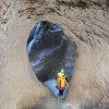
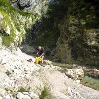
Direkt bei der Brücke, die über die Zemola führt, gibt es eine kleine Kapelle. Hinter der Kapelle führt ein schmaler Pfad kurz hoch und dann direkt neben der Schlucht, ohne großen Höhenunterschied, bis zu einer Betonierten Mauer. Von diesen gelangt man über eine kurze Abkletterpassage zum Bach/Einstieg des unteren Teils auf ca. 810Hm. Für den oberen Einstieg bleibt man auf den Pfad für weitere 10-15min bis die Schlucht offener wird und man ein Blockchaos sieht. Hier ist der Einstieg des oberen Teils (860 Hm)
Right by the bridge that crosses the Zemola, there is a small chapel. Behind the chapel, a narrow sloping path leads briefly up and then directly next to the canyon, without much difference in altitude, to a concreted wall. From these, a short downclimb takes you to the stream/entry of the lower part at about 810Hm. For the upper entry, stay on the path for another 10-15min until the canyon becomes more open and you see a mess of boulders. Here is the entry of the upper part (860 Hm)
Tour (2 h 45):
machine translated
➜
Original language
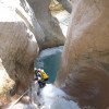
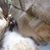
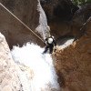
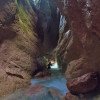
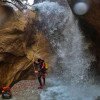
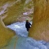
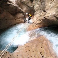
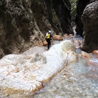
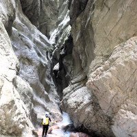
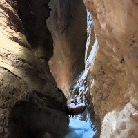
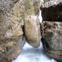
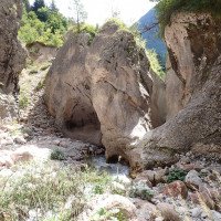
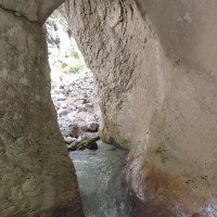
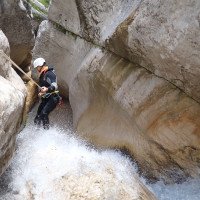
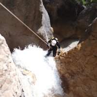
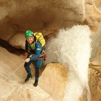
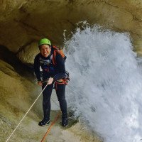
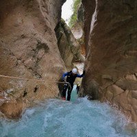
Ohne große Wegstrecke geht es gleich los mit Abkletter und Abseilpassagen in turbulente Gumpen. Der Wasserstand sollte vor der Tour unbedingt überprüft werden, da die schon ohnehin turbulenten Becken, sehr starke Strömungen/Rückläufe bilden können. Die Standplätze sind sehr gut angebracht. Das Abseilen im Wasser ist jedoch unausweichlich. Einige ausgesetzte Standplätze werden über zu bauende Geländerseil erreicht. Zur Mittagszeit kommt am meisten Sonne in den sehr schönen eng eingeschnittenen Mittelteil. Ein kurzer Abschnitt am Schluss des eingeschnittenen Teils ist fast komplett dunkel (evtl. Lampe mitnehmen). Nach dem dunklen Abschnitt öffnet sich die Schlucht wieder. Es folgt eine sehr schöne Stelle mit einem ausgewaschenen Felsbogen in den das Wasser hindurchfließt. Der Kettenstand befindet sich in der Mitte hinten am Felsbogen. Der Abseiler führt in einen großen Gumpen mit starker Strömung. Nach dieser Stelle kommen noch 3 weitere spektakuläre Abseilstellen in schönster Umgebung. Zu bauende Seilgeländer helfen um sicher an die Standplötze bzw. über die Abseilstellen zu kommen. Am Schluss, wo sich die Schlucht Zusehens öffnet, färbt sich das Gestein rot. Nach kurzer Wegstrecke im Bach findet man auf einen Felsen re einen blauen Punkt, der den Ausstieg auf ca. 670Hm markiert.
Without much distance, it starts immediately with downclimb and rappel passages in turbulent pools. The water level should be checked before the tour, because the already turbulent pools can form very strong currents / backflows. The belay stations are very well placed. However, rappeling in the water is unavoidable. Some exposed belay stations are reached via traverese rope to be built. At midday the most sun comes to the very nice narrow cut middle section. A short section at the end of the cut part is almost completely dark (possibly take a lamp). After the dark part, the canyon opens up again. There follows a very beautiful place with a washed out rock arch in which the water flows through. The piton is located in the middle at the back of the rock arch. The rappel leads into a large pool with a strong current. After this point there are 3 more spectacular rappels in the most beautiful surroundings. Rope traverses to be built help to get safely to the belay blocks or over the rappels. At the end, where the canyon opens up, the rock turns red. After a short stretch in the stream, you will find a blue dot on a rock to the right, which marks the exit at about 670Hm.
Return (15 min):
machine translated
➜
Original language
Von der Markierung geht es re über den schmalen Schotterweg steil bergauf. Mit raschem Höhengewinn geht es in den bewaldeten Teil, bevor man wieder zur Straße/Parkplatz gelangt.
From the marker, go steeply uphill on the right along the narrow gravel road. With a rapid gain in altitude, it goes into the wooded part before returning to the road / parking lot.
Coordinates:
Canyon Start
Alternative Canyon Start
Alternativeinstieg für unteren Teil
Parking at Entry
Parkplatz für den Einstieg ins Val Zemola (migrated from 1097)
Parking at Exit
Canyon End
Literatures:
Canyoning Book
CANYONING Nord Italia (Pascal van Duin; 2009)
Canyoning Book
Canyoning IN DOLOMITI e DINTORNI
Matteo Bortot, Roberto Sartor
ViviDolomiti
2019
45 Canyon-Beschreibungen
ACA Canyon Info
Cwiki Canyon Info
Descente Canyon Info
Ropewiki Canyon Info
Video
AIC Catasto
Other Canyon Info
Gallery
Other Canyon Info
Other Canyon Info
Trip Report (e.g. Blogpost)
New Report
09.05.2024
Horst Lambauer
⭐
★★★★★
📖
★★★
⚓
★★★
🌊
Crazy
Completed ✔
machine translated
➜
Original language
Auch mit dabei waren: Wolfgang Rok
Wieder mal senstionell, aber sehr sportliches Wasser. Haben ca 3,5h Auto- Auto benötigt. Treibanker sollte man bei diesem Wasserstand mit dabei haben (siehe Fotos)
Once again sensational, but very sporty water. We needed about 3.5 hours car-car. You should have a floating anchor with you at this water level (see photos)
Auch mit dabei waren: Wolfgang Rok
11.10.2023
Joey CIA
⭐
★★★★★
📖
★★★
⚓
★★★
💧
Normal
Completed ✔
machine translated
➜
Original language
Stände alle super! Tolle Tour bei super Bedingungen mit der Sonne übern Mittag.
Ende des kurzen Dunkelteils liegen zwei Unterschenkel eines großen Rehs und beim Stand Nr.5 hängt ein Reh im Minipool rechts,da besser nicht ins Wasser...riecht ziemlich!
Stands all super! Great tour in great conditions with the sun over midday.
End of the short dark part lie two lower legs of a large deer and at Stand Nr.5 hangs a deer in the mini pool right, because better not in the water ... smells pretty!
15.08.2023
Wolfgang
⭐
★★★★★
📖
★★★
⚓
★★★
💧
High
Completed ✔
machine translated
➜
Original language
Bei tollem Wetter "ganz rauf marschiert"
Wasser war OK , für perfektes Licht waren wir halt etwas zu spät am NM
In great weather "marched all the way up".
Water was OK, for perfect light we were just a little too late at the NM
14.08.2023
Wolfgang Streicher
⭐
★★★★★
📖
★★★
⚓
★★★
Completed ✔
machine translated
➜
Original language

Unterer Einstieg. Alle Stände ok. Wasserstand etwas höher als um diese Jahreszeit üblich.
Lower entry. All stands ok. Water level slightly higher than usual at this time of year.
09.05.2023
Christian Balla
⭐
★★★★★
📖
★★★
⚓
★★★
💧
High
Completed ✔
machine translated
➜
Original language
Sehr viel Wasser aber mit entsprechender Erfahrung noch gut machbar
Very much water but with appropriate experience still well doable
27.04.2023
System User
⭐
★★★★★
📖
★★★
⚓
★★★
no translation available
Der aktuelle Canyon wurde teilautomatisiert mit Canyon https://canyon.carto.net/cwiki/bin/view/Canyons/ValZemolaCanyon.html zusammengeführt.
09.03.2023
System User
⭐
★★★★★
📖
★★★
⚓
★★★
no translation available
Daten importiert von https://canyon.carto.net/cwiki/bin/view/Canyons/ValZemolaCanyon.html
09.03.2023
System User
⭐
★★★★★
📖
★★★
⚓
★★★
no translation available
Info: Teile der Canyonbeschreibung wurden automatisiert übernommen. Konkret die Felder Weblinks, Koordinaten, Rating, Länge des Canyon, Einfachseil Mindestens von https://www.descente-canyon.com/canyoning/canyon/2529
09.03.2023
System User
⭐
★★★★★
📖
★★★
⚓
★★★
no translation available
Daten importiert von https://www.canyoning.or.at/index.php/liste-aller-canyons/78-zemola-inferiore
17.08.2019
Christian Balla
⭐
★★★★★
📖
★★★
⚓
★★★
💧
Normal
Completed ✔
machine translated
➜
Original language
Im Zemola erwartet einem ein sehr beeindruckender Canyon mit vielen schönen Abseilstellen. Der Canyon ist tief eingeschnitten und abwechslungsreich. Am Ende ein Geysir.
Zustieg mit Umparken:
Der Abstieg vom Parkplatz zum Canyon ist etwas müßig und dauert fast 1 Stunde. Umparken bringt keinen Zeit-vorteil und stellt keine signifikante Erleichterung beim Zustieg dar.
Zustieg ohne Umparken:
Gut Eingerichteter Zustieg entlang des Canyons. Es gibt zahlreiche Seilgeländer, Canyoning Gurt sollte daher verwendet werden. Dauer ca 30 Minuten.
Rückweg:
Müßiger Rückweg durch den Wald den Berg hinauf zur Straße
Video zur Tour:
https://www.youtube.com/watch?v=BGWQK_d8l98
Fotos und GPS Tracks:
https://www.christian-balla.de/Zemola
A very impressive canyon with many beautiful abseiling spots awaits you in Zemola. The canyon is deeply cut and varied. A geyser at the exit.
Access with re-parking:
The descent from the parking lot to the canyon is somewhat tedious and takes almost 1 hour. Reparking does not save any time and does not make access any easier.
Access without parking:
Well-established access along the canyon. There are numerous rope traverses, so a canyoning harness should be used. Duration approx. 30 minutes.
Way back:
A leisurely walk back through the forest up the mountain to the road
Video of the tour:
https://www.youtube.com/watch?v=BGWQK_d8l98
Photos and GPS tracks:
https://www.christian-balla.de/Zemola
Hydrology:
1 mittlerer Einstieg

2 auf dem Weg zum 1. Absei...

3 1. Abseiler

4

5
6

7
8
9
10

11
12
13 vor der Schlusspassage

14
15

15
17 vorletzter Abseiler
18 letzter Abseiler

19 dito

20 letztes "Hindernis" vor...
letzter Abseiler bei normale...
letzter Abseiler bei extreme...

vgl 15, hier bei extrem viel...

letzter Abseiler bei extreme...

letzter Abseiler bei extreme...