Country:
Italia / Italy
Region: Friuli Venezia Giulia
Subregion: Udine
Town: Roveredo
v3 a2 II
3h55
1h10
2h30
15min
730m
515m
215m
40m
2x40m
12
on Foot
Rating:
★★★★★
2.8 (6)
Info:
★★★
1.7 (4)
Belay:
★★★
2 (5)
Summary:
machine translated
➜
Original language
Gemütliche offene und kontinuierliche Kalkschlucht; meist wenig Wasser; interessant nach Regenfällen; Abseiler meist in der Wasserführung; seichte Gumpen; Absicherung oben sehr gut (10mm Inox) unten ausreichend (Schlingen) evtl. Schlingen Ersatz mitnehmen; Nachbar-Canyon von Rio Simon; Halbtagestour.
Interessant für Tage an denen die Begehung anderer Schluchten ausgeschlossen ist!
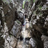
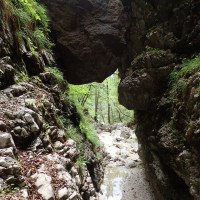
Comfortable open and continuous lime canyon; mostly little water; interesting after rains; rappel mostly in the water flow; shallow pools; belay very good at the top (10mm Inox) sufficient at the bottom (slings) possibly take spare slings; neighboring canyon of Rio Simon; half-day tour.
Interesting for days on which the access to other canyons is excluded!
East
Limestone
Summary:
machine translated
➜
Original language
Gemütliche offene und kontinuierliche Kalkschlucht; meist wenig Wasser; interessant nach Regenfällen; Abseiler meist in der Wasserführung; seichte Gumpen; Absicherung oben sehr gut (10mm Inox) unten ausreichend (Schlingen) evtl. Schlingen Ersatz mitnehmen; Nachbar-Canyon von Rio Simon; Halbtagestour.
Interessant für Tage an denen die Begehung anderer Schluchten ausgeschlossen ist!
Comfortable open and continuous lime canyon; mostly little water; interesting after rains; rappel mostly in the water flow; shallow pools; belay very good at the top (10mm Inox) sufficient at the bottom (slings) possibly take spare slings; neighboring canyon of Rio Simon; half-day tour.
Interesting for days on which the access to other canyons is excluded!
Access:
machine translated
➜
Original language
Von Carnia fährt man auf der SS13 (Bundesstraße) Richtung Tarvisio. Ca. 3km nach der Ortschaft Resiutta kommt ein kleiner Tunnel und eine Brücke über den Fella Fluss. Nach der Brücke links abbiegen und weiter Richtung Roveredo. Zu Beginn der Ortschaft Roveredo gibt es auf der rechten Straßenseite eine kleine Auffahrt zu einem großen betonierten Parkplatz. Hier parkt man das Auto.
From Carnia take the SS13 in the direction of Tarvisio. About 3km after the village of Resiutta there is a small tunnel and a bridge over the Fella river. After the bridge turn left and continue towards Roveredo. At the beginning of Roveredo, on the right side of the road, there is a small driveway leading to a large concrete parking lot. Here you park the car.
Approach (1 h 10):
machine translated
➜
Original language
Vom Parkplatz geht man retour über den Rio Brezzi. Nach der Kurve beginnt links ein steiler Steig markiert mit einen gr 70 den Wald hoch. Man folgt den Steigspuren nach oben zum Weg 424. Meist gibt es verschieden Steigspuren , auf jeden Fall muss man rauf zum Weg - derzeit (stand Herbst 2023) führt der Steig schon unterhalb von 424 Weg über den Brezzi und man kommt direkt zur Abzweigung vom Pfad der weiter zum Einstieg führt (siehe Openstreet map oder Koordinaten unten) Nach mehreren Höhenmeter bei ca. 730m verlässt man den Pfad rechts an der Stelle wo der Pfad markant nach links wegzieht. Hier kurz (2min) und Weglos in den Bach absteigen. Der ganz Pfad ist auf Open street map gut eingezeichnet.
From the parking lot, follow the road further through the village until you reach the bus stop/water house with trail markings. After the bus stop there is a small wall with the blue/white canyoning marking. Here follow the steep path next to the fence up into the forest. After a few minutes you will meet trail 424 (this is also the trail that leads to Rio Simon). Be careful to follow the path 424 on the right only for about 100m (50m further you are already at the exit of the Rio Brezzi where you can also check the water level before the tour). For the further access you follow 50m before the creek on the left a steep path (or. on the right side of the creek /some orange color markings on the trees) which is inconspicuous at the beginning. After several meters of ascent (approx. 45min.), look out for a cord tied around the tree at approx. 730m on the right. If the cord is no longer there, leave the path on the right at the point where the path moves away sharply to the left. Descend here briefly (2min) and without a trail into the stream.
Tour (2 h 30):
machine translated
➜
Original language
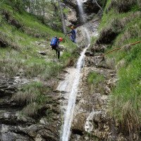
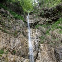
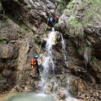
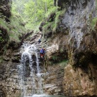
Ein paar Meter nach dem Einstieg kommt gleich die höchste Abseilstelle von 40m (rechts). Ohne Wegstrecke folgen zwei ca. 20m Abseiler bevor man vor einen großen Klemmblock eine Stufe abklettert. Nach dem Klemmblock folgen im offenen bewaldeten Schluchtengelände noch acht weitere Abseilstellen bis max. 22m. Abgeseilt wird meist über Baumschlingen oder Ausgleichsverankerungen im Wasser. Sollte der Wasserstand mal unerwartet hoch sein, kann jederzeit auf der rechten Seite zum Zustiegspfad ausgestiegen werden. Bei ca. 510m quert man wieder am Zustiegsweg 424. (Hier könnte man aussteigen und dem Wanderweg zum Parkplatz folgen) Jetzt kommen noch 3-4 absolut nette Abseiler bis man direkt bei der Straße rechts aussteigen kann.
A few meters after the entry comes the highest rappel point of 40m (right). Two rappels of about 20m follow without any path before you climb down a step in front of a large clamping block. After the clamping block, eight more rappels up to a maximum of 22m follow in the open wooded canyon terrain. The rappeling is mostly done via tree loops or compensation anchorages in the water. Should the water level be unexpectedly high, you can always get off on the right side to the access path. At the end of the tour at approx. 510m you are back at the access path 424. Here you usually get off because two more steps after the hiking trail are not worthwhile (see alternative way back).
Return (15 min):
machine translated
➜
Original language
Bei der Straßenbrücke rechts aufsteigen und 1 min retour zum Parkplatz
Either follow path 424 to the right until you reach the fork and then take the path on the left that you took during the access down to the village to the parking lot, or continue descending in the streambed and after two more rappels before getting off at the road bridge in the village.
Coordinates:
Canyon Start
Canyon End
Parking Entry and Exit
46.39806°, 13.24991°
↓↑
DMS: 46° 23" 53.02', 13° 14" 59.68'
DM: 46° 23.884", 13° 14.995"
Google Maps
DMS: 46° 23" 53.02', 13° 14" 59.68'
DM: 46° 23.884", 13° 14.995"
Google Maps
Waypoint
46.399948°, 13.250723°
↓↑
DMS: 46° 23" 59.81', 13° 15" 2.6'
DM: 46° 23.997", 13° 15.043"
Google Maps
DMS: 46° 23" 59.81', 13° 15" 2.6'
DM: 46° 23.997", 13° 15.043"
Google Maps
Abzweigung Weg 424 / Zustiegspfad
Literatures:
Map
Tabacco 18, Alpi Carniche Orientali - Canal del Ferro, 1:25 000
Map
IGMI 25/V, 14 Chiusaforte II-SO, 1:25 000
Cwiki Canyon Info
Ropewiki Canyon Info
New Report
04.05.2024
Georg Rudelstorfer
⭐
★★★★★
📖
★★★
⚓
★★★
💧
Normal
Completed ✔
machine translated
➜
Original language
Auch mit dabei waren: Theresa Prandstätter
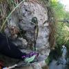
Durchgehend steiler Zustieg. Abstiegszeit angepasst da ich 2h bis ganz runter als sehr sportlich empfinde. 2:30 bis zum 1. Ausstieg und 3h bis zur Straße sollten machbar sein. Ich kann mich Horst anschließen einige Schlingen könnten bereits erneuert werden. Großteils ist aber alles noch in Ordnung bis auf den ersten Abseiler nach dem möglichen Ausstieg (siehe Foto) hier falls möglich einen zweiten Anker setzen und mit Maillon Glied ausrüsten.
Steep access throughout. Descent time adjusted as I find 2h to the bottom very sporty. 2:30 to the 1st exit and 3h to the road should be doable. I can agree with Horst that some of the slings could be renewed. For the most part, however, everything is still in order except for the first rappel after the possible exit (see photo). If possible, place a second anchor here and equip it with a maillon link.
Auch mit dabei waren: Theresa Prandstätter
13.04.2024
Horst Lambauer
⭐
★★★★★
📖
★★★
⚓
★★★
💧
Low
Completed ✔
machine translated
➜
Original language
Auch mit dabei waren: Wolfgang
Stände sind zu weit OK. wenn der nächste in die Schlucht geht wäre es ganz gut ein seil mitzunehmen um ein paar Schlingen zu tauschen
Stands are too far OK. if the next one goes into the canyon it would be quite good to take a rope with you to swap a few canyons
Auch mit dabei waren: Wolfgang
27.11.2023
Wolfgang
⭐
★★★★★
📖
★★★
⚓
★★★
💧
Normal
Completed ✔
machine translated
➜
Original language
Für den Zustieg kann man grob OSM folgen , wobei sich derzeit die Steigspuren optimiert haben und direkt zur Abzweigung vom 424 führen. Durch die heftigen Regenfälle im Oktober fanden wir eine super durchgeputzte Schlucht vor; Wasser war auch noch ausreichend vorhanden. Für mich gibt es absolut keinen Grund beim Weg 424 auszusteigen und runter zu wandern. Es folgen noch 4 gut eingerichtet nette Abseiler. Die Stände haben das Hochwasser gut überstanden.
Unsere Zeiten gemütlich 2 Personen. Zustieg 50min ; Canyon ganz runter 1h50min
For the approach you can roughly follow OSM, whereby the climbing tracks have currently been optimized and lead directly to the junction of the 424. Due to the heavy rainfall in October, we found a super clean gorge; there was also plenty of water. For me, there is absolutely no reason to get off trail 424 and hike down. This is followed by 4 well-equipped, nice abseils. The stands have survived the flood well.
Our times are comfortable for 2 people. Approach 50min ; Canyon all the way down 1h50min
23.09.2023
Clarissa Linder
⭐
★★★★★
📖
★★★
⚓
★★★
💧
Normal
Completed ✔
machine translated
➜
Original language
Begehung nach Regenfall. Alle Stände top.
Walk-in after rainfall. All stands top.
20.05.2023
Thomas Fras
⭐
★★★★★
📖
★★★
⚓
★★★
💧
Low
Completed ✔
machine translated
➜
Original language
Alle oberen Stände würden saniert (inox Kettenstand und Wingrings). Unten weiterhin Ausgleichsverankerungen, Baumschlingen.
Neue Reepschnur am Baum wo man den Wanderweg zum Bach/Einstieg verlässt.
All upper stands would be rehabilitated (inox chain stand and wingrings). Bottom continues to have balance anchors, tree slings.
New rep cord on tree where you leave trail to creek/entrance.
11.04.2023
Daniel Sturm
⭐
★★★★★
📖
★★★
⚓
★★★
Completed ✕
machine translated
➜
Original language
Koordinaten und Beschreibung bearbeitet.
Coordinates and description edited.
09.03.2023
System User
⭐
★★★★★
📖
★★★
⚓
★★★
no translation available
Daten importiert von https://canyon.carto.net/cwiki/bin/view/Canyons/BrezziCanyon.html
Hydrology: