a little difficult
Torrent Valldemossa
Country:
España / Spain
Region: Islas Baleares / Balearic Islands
Subregion: Islas Baleares / Balearic Islands
Town: Valdemossa
v4 a3 III
3h20
5min
3h
15min
280m
30m
250m
55m
2x60m
15
600m
Car optional
Rating:
★★★★★
2.7 (2)
Info:
★★★
2 (1)
Belay:
★★★
3 (1)
Summary:
machine translated
➜
Original language
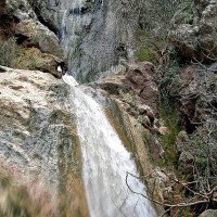
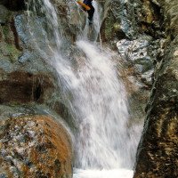
Wie auch viele andere Canyons in Mallorca zum Sommer hin kaum mehr Wasserdurchsatz. Schöne, zT. auch hohe Abseiler, meist versintert.
Like many other canyons in Mallorca towards the summer hardly more water flow. Beautiful, zT. also high rappel, mostly sintered.
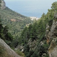
Northwest
Limestone
Summary:
machine translated
➜
Original language
Wie auch viele andere Canyons in Mallorca zum Sommer hin kaum mehr Wasserdurchsatz. Schöne, zT. auch hohe Abseiler, meist versintert.
Like many other canyons in Mallorca towards the summer hardly more water flow. Beautiful, zT. also high rappel, mostly sintered.
Access:
machine translated
➜
Original language
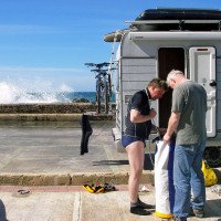
Den Autobahnring um Palma über die Ausfahrt 58 auf die Ma1110 verlassen und nordwärts. Nach 6,8 km am Kreisverkehr bei den verstreuten Häusern von S'Esgleieta (rechterhand ein Restaurant) weiter auf der Ma 1110 in nördlicher Richtung. Nach weiteren 7,9 km erreichen wir das Zentrum von Valldemossa. Weiter geht es - nun auf der Ma1130 - in Richtung Andratx. Nach etwa 900m lassen wir die Straßenabzweigung nach Soller rechts liegen und kommen etwa 400m weiter zur Abzweigung (rechts, NNW) in Richtung Port/Marina de Valldemossa. Wir biegen hier auf die Ma1131 ab und fahren hinunter nach Port de Valldemossa (noch einmal 5,4km). Hier suchen wir uns einen passenden Parkplatz in der Nähe des Ortsanfangs.\nMit dem zweiten Auto fahten wir wieder 4,3 km zurück und hinauf zur Hochfläche. Am besten stellt man hier das Auto schon vor den Häusern des Weilers Son Mas ab.
Exit the Palma ring road at exit 58 onto the Ma1110 and head north. After 6.8 km, at the traffic circle by the scattered houses of S'Esgleieta (a restaurant on the righthand side), continue north on the Ma 1110. After another 7.9 km we reach the center of Valldemossa. We continue - now on the Ma1130 - in the direction of Andratx. After about 900m we leave the road junction to Soller on the right and about 400m further we come to the junction (right, NNW) in the direction of Port/Marina de Valldemossa. We turn here on the Ma1131 and go down to Port de Valldemossa (another 5,4km). Here we look for a suitable parking lot near the beginning of the village.\nWith the second car we drove back again 4.3 km and up to the plateau. It is best to leave the car here already in front of the houses of the hamlet Son Mas.
Approach (5 min):
machine translated
➜
Original language
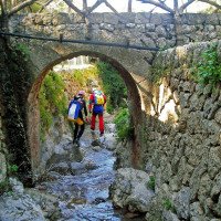
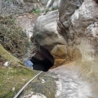
Orograf. links von der Brücke einige Meter bachab kommen wir in's Bachbett. Im Buch "L'illa dels torrents" von Barceló/Trias wird ein Zustieg von der orograf. rechten Bachseite direkt von dem vor dem Weiler geparkten Auto beschrieben.\nAuch der Alternativeinstieg über den Torrent Rafal führt zwangsläufig über Privatgrund.
Orograf. left of the bridge a few meters downstream we come into the streambed. In the book "L'illa dels torrents" by Barceló/Trias is described an access from the orographic right side of the stream directly from the car parked in front of the hamlet.\nAlso the alternative access via the Torrent Rafal leads inevitably over private land.
Tour (3 h):
machine translated
➜
Original language
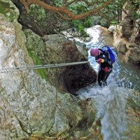
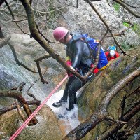
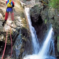
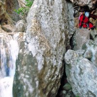
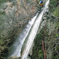
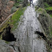
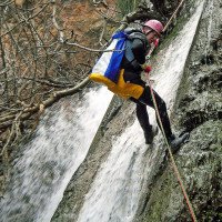
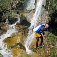
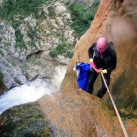
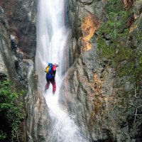
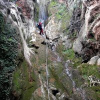
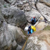
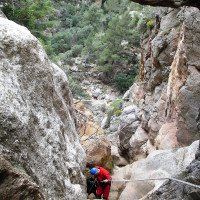
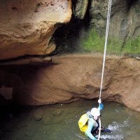
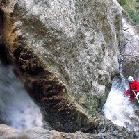
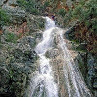
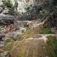
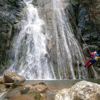
Wir klettern bzw. seilen im Bachbett abwärts. Nach etwa 200m plätschert von links oben das Wasser des Torrent Rafal herab. Hier ist bei entsprechend befülltem Gumpen ein Sprung möglich. Das ist dann auch in der Folge mehrfach der Fall. Neben einigen Abseilern über 20 bis 35 Meter stoßen wir auch auf den "Gan Salta" mit 55m (insgesamt etwa 15 Abseiler). Unten angekommen laufen und klettern wir im Bachbett weiter abwärts.
We climb or ropes in the streambed down. After about 200m the water of the Torrent Rafal splashes down from the upper left. Here, if the pool is filled, a jump is possible. This is then also the case several times in the following. In addition to several rappels over 20 to 35 meters, we also encounter the "Gan Salta" with 55m (a total of about 10 - 13 rappels). At the bottom we walk and climb in the streambed further down.
Return (15 min):
machine translated
➜
Original language
Vor einem großen Felsen im Bachbett rechts hinaus zur Straße und auf dieser abwärts zum Auto.
In front of a large rock in the streambed, turn right out to the road and downhill to the car.
Coordinates:
Canyon Start
Canyon End
Parking at Exit
Ortseinfahrt
Parking at Entry
noch vor der Linkskurve, nach der die Straße direkt auf den Ort zuläuft
Literatures:
Map
Wanderkarte /Hiking Map Mallorca - Serra de Tramuntana Süd /South, 1/25000 - 2009
Map
Mallorca - Wanderkarte 1:35.000 (Kartenset mit Nord + Süd-Blatt) - 2015
Map
IGN MTN50 670 (38-26) Sóller 1:50.000
Map
http://www.wikiloc.com/wikiloc/view.do?id=9117933
Canyoning Book
Balearik 2016. Damon McShane Armstrong, 2016
Canyoning Book
L'illa dels torrents - Guia Torrentera de Mallorca, Barceló/Trias, 2014
Canyoning Book
Mallorca Canyons. Topo-Map Guide. Damon McShane Armstrong, 2014
Canyoning Book
Guía de Torrentes y Cavidades. Mallorca. Asociación Balearik, 2013
Canyoning Book
Guía de Mallorca. Balearik 2012. Damon McShane Armstrong, 2012
Canyoning Book
EAB & Balearik Damon J. McShane Armstrong, 2011
Canyoning Book
Canyons aux Baléares, Thierry/Achmétoff, 2004
Canyoning Book
Asturias, Cuenca, Granada, Mallorca, Tarragona y Terruel - Guia de descenso de cañones y barrancos, Gomez/Tejero, 2004
Canyoning Book
Els torrents clàssics de la Serra de Tramuntana, Trias/Ramon, 2000
Canyoning Book
Descenso de cañones. Mallorca - Tomo I. Eduardo Gómez, 1998
Canyoning Book
La gran aventura. Lluis Vallcaneras y otros, 1995
Canyoning Book
Gorgas y barrancos de Cataluña, Mallorca y Alto Esera. Eduardo Gómez - Miquel Soro, 1993
Cwiki Canyon Info
Descente Canyon Info
Ropewiki Canyon Info
Other Canyon Info
New Report
26.03.2024
Klara Skopal
⭐
★★★★★
📖
★★★
⚓
★★★
💧
Dry
Completed ✔
machine translated
➜
Original language
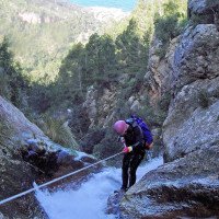
Trotz der angeblich besten Jahreszeit vollkommen trocken bis auf ein paar abgestandene Lacken. Der "Zufluss" von links war ein süßes Tröpfeln, also weiterhin staubtrocken, auch die Gumpen vollkommen leer, daher teils aufpassen, dass man nicht zu weit in die leeren Gumpen abseilt.
Nur einer würde fürs Rauskommen Probleme bereiten, dort ist aber ein Fixseil als Aufstiegshilfe montiert.
Daher jedoch viele Abseilstellen abkletterbar, Stein grundsätzlich recht griffig.
Wir haben uns im Neo totgeschwitzt, wäre aktuell mit T-Shirt und Hose auch gegangen :)
Sinterformationen sind schön aber ohne Wasser insgesamt wenig lohnend.
Zwischenzeitlich auch Handyempfang möglich, da die Schlucht sehr offen ist
Despite the supposedly best time of year, completely dry except for a few stale pools. The "inflow" from the left was a sweet trickle, so still dry as dust, the pools also completely empty, so be careful not to rappel too far into the empty pools.
Only one would cause problems for getting out, but there is a fixed rope mounted there as an ascent aid.
However, many of the abseiling sections can be climbed down, and the rock is generally quite grippy.
We sweated ourselves to death in our wetsuits, but would have been fine in a T-shirt and trousers :)
Sinter formations are beautiful but not very rewarding without water.
Cell phone reception is also possible in the meantime, as the canyon is very open
09.03.2023
System User
⭐
★★★★★
📖
★★★
⚓
★★★
no translation available
Daten importiert von https://canyon.carto.net/cwiki/bin/view/Canyons/TorrentValldemossaCanyon.html
Hydrology: