Country:
Deutschland / Germany
Region: Oberbayern / Upper Bavaria
Subregion: Landkreis Berchtesgadener Land
Town: Marktschellenberg
v3 a2 II
1h35
20min
1h15
0min
600m
500m
100m
25m
2x30m
4
on Foot
Rating:
★★★★★
2.8 (6)
Info:
★★★
3 (4)
Belay:
★★★
2.8 (4)
Summary:
machine translated
➜
Original language
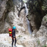
Kurze, schöne Tour; sauberes, kaltes Wasser; kurzer Zustieg; bei hohen Wasserstand (Schmelzwasser) jedoch nicht zu unterschätzen; Kalkgestein (Untersberger Marmor).
Short, beautiful tour; clean, cold water; short access; at high water levels, however, dangerous single spots; limestone (untersberg marble).
East
Limestone
Summary:
machine translated
➜
Original language
Kurze, schöne Tour; sauberes, kaltes Wasser; kurzer Zustieg; bei hohen Wasserstand (Schmelzwasser) jedoch nicht zu unterschätzen; Kalkgestein (Untersberger Marmor).
Short, beautiful tour; clean, cold water; short access; at high water levels, however, dangerous single spots; limestone (untersberg marble).
Access:
machine translated
➜
Original language
Von Sbg. Süd fährt man auf der B305 immer gerade aus in Richtung Berchtesgaden (D) --> ca. 500m nach der Grenze (St.Leonhard) kommt eine kleine Brücke (Verkehrsschild 24t) --> gleich nach der Brücke hat man re eine kleine 90° Einfahrt mit Parkmöglichkeit im Wald.
approx. 10min
From Sbg. south one drives on the B305 always straight ahead in the direction of Berchtesgaden (D) --> approx. 500m after the border (St.Leonhard) comes a small bridge (yellow round sign 24/24) --> immediately after the bridge one has right a small entrance with parking possibility in the forest (approx. 530m).
Approach (20 min):
machine translated
➜
Original language
Über den Bach oder von der Straße aus, gelangt man auf dem breiten Wanderweg (Kienbergsteig) der rechts in den Wald hoch führt (orografisch links neben dem Verkehrsschild 24t)--> nach einigen Hm kommt man zu einer kl. Waldlichtung mit Weggabelung, hier folgt den nun schmaleren steilen Weg links --> nach kurzer Strecke kommt die nächste kleine Weggabelung --> hier den gut sichtbaren Pfad links ohne großen Höhenunterschied oberhalb der Schlucht in Richtung Bach folgen. Hier fängt auf ca. 600Hm der Interessante Teil der Schlucht an.(Folgt man den Kienbergsteig, könnte man weiter oben auch in den Bach einsteigen, ist jedoch weniger interessant da ca.40min Geh/Abkletterpassagen).
approx. 25min
Across the creek or from the road, you reach the wide hiking trail that leads up into the forest on the right (or.li.)--> after a few meters there is a fork, here follow the narrow steep path on the left --> parallel to the canyon it continues up --> at about 690m the path becomes flatter for a short time, here immediately at the first steep grassy slope descend on the left or rappel over trees into the canyon (a little further up you could also enter the canyon, but it is less interesting) entry at about 660Hm.
Tour (1 h 15):
machine translated
➜
Original language
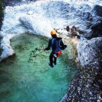
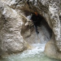
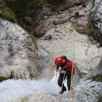
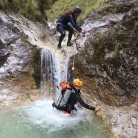
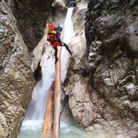
Die eher offene Weißbachschlucht hat zwei ca.25m hohe und mehrere kleine Abseilstellen --> je nach Wasserstand können die kleinen Stufen oft auch abgeklettert werden --> bei normalen Wasserstand ist die gut eingerichtete Schlucht auch für Einsteiger geeignet --> zwischen den Stufen (Abseilstellen) gibt es kurze Gehpassagen und kleine Rutschen mit Auswaschungen --> nach der letzten ca. 8m Abseilstelle wird es flach --> es folgt eine ca. 10min Gehstrecke im flachen Bachbett bis zum Ausgangspunkt (ca.500m).
approx. 1-1,5h
The rather open Weißbach canyon has two approx. 25m high and several small downclimbing passages --> depending on the water level, the small steps can often also be climbed down --> at normal water levels, the well-equipped canyon is also suitable for beginners --> between the steps (downclimbing passages) there are short walking passages and small slides with washouts --> after the last approx. 8m downclimbing passage, it becomes flat --> the last boulders are still climbed down before it then goes approx. 10min in the flat streambed to the starting point.
Return (0 min):
machine translated
➜
Original language
Vom flachen Bachbett stiegt man re direkt zum Parkplatz aus.
ca.0min
From the shallow streambed descended right directly to the parking lot.
Coordinates:
Canyon Start
Canyon End
Literatures:
Canyoning Book
DCV 20 Jahre
Deutscher Canyoning Verein
2015
Booklet mit 13 Canyon-Beschreibungen
ACA Canyon Info
Cwiki Canyon Info
New Report
28.04.2024
Thomas Fras
⭐
★★★★★
📖
★★★
⚓
★★★
💧
High
Completed ✔
machine translated
➜
Original language
Alle Standplätze ok, viel Schmelzwasser, neue Topo gezeichnet
All pitches ok, lots of meltwater, new topographic view drawn
09.11.2023
Daniel Sturm
⭐
★★★★★
📖
★★★
⚓
★★★
💧
Normal
Completed ✔
machine translated
➜
Original language
Siehe Bewertung von Christoph
See review by Christoph
09.11.2023
Christoph Cramer
⭐
★★★★★
📖
★★★
⚓
★★★
💧
Normal
Completed ✔
machine translated
➜
Original language
Stände in Ordnung, Pools überwiegend flach.
Beaches in order, pools mostly shallow.
10.06.2023
Thomas Fras
⭐
★★★★★
📖
★★★
⚓
★★★
💧
Normal
Completed ✔
machine translated
➜
Original language
Alle Standplätze ok, querliegende Bäume am Schluchtenausgang wurden zersägt, alles top, zwei neue Baumschlingen beim steilen Grashang in den Bach
All stands ok, crosscut trees at canyon exit were sawed, all top, two new tree loops at steep grass slope into creek
09.03.2023
System User
⭐
★★★★★
📖
★★★
⚓
★★★
no translation available
Info: Teile der Canyonbeschreibung wurden automatisiert übernommen. Konkret die Felder Weblinks, Koordinaten, Rating, Ort, Länge des Canyon, Einfachseil Mindestens von https://canyon.carto.net/cwiki/bin/view/Canyons/WeissbachCanyon.html und https://www.descente-canyon.com/canyoning/canyon/23817
09.03.2023
System User
⭐
★★★★★
📖
★★★
⚓
★★★
no translation available
Daten importiert von https://www.canyoning.or.at/index.php/liste-aller-canyons/91-weissbach
Hydrology: