a little difficult
Val Progero (inferiore)
Country:
Schweiz / Switzerland
Region: Kanton Tessin / Cantone Ticino
Subregion: Bezirk Bellinzona
Town: Progero
v4 a4 II
4h5
35min
3h20
10min
460m
270m
190m
45m
2x 50m
10
400m
on Foot
Rating:
★★★★★
2.8 (2)
Info:
★★★
2 (2)
Belay:
★★★
2 (1)
Summary:
machine translated
➜
Original language
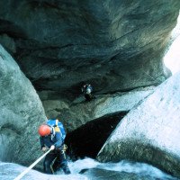
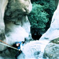
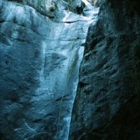
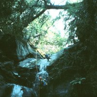
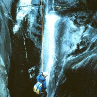
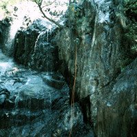
Abseilcanyon mit z.T. etwas düsterem Ambiente.
Rappel canyon with partly somewhat gloomy ambience.
May - October
10-15 o clock
South
Summary:
machine translated
➜
Original language
Abseilcanyon mit z.T. etwas düsterem Ambiente.
Rappel canyon with partly somewhat gloomy ambience.
Access:
machine translated
➜
Original language
Von Bellinzona auf der rechtsufrig am Ticino entlangführenden Landstraße in Richtung Tenero und Locarno. Man durchquert die Ortschaft Sementina und ca. 3 km nach Sementina zweigt man von der Hauptstraße nach rechts ab in die Ortschaft Gudo. 300 m nach der Abzweigung von der Hauptstraße fährt man nach der Kirche rechts hoch, gleich wieder links und dann 600 m geradeaus weiter. Man erreicht eine 180°-Rechtskehre, nach der auf der rechten Seite eine gute Parkmöglichkeit besteht.
From Bellinzona, take the road along the right bank of the Ticino in the direction of Tenero and Locarno. Pass through the village of Sementina and about 3 km after Sementina turn right off the main road into the village of Gudo. 300 m after the turn-off from the main road, after the church, go up to the right, immediately turn left again and go straight on for 600 m. You reach a 180° right turn. You reach a 180° rightward haipin bend, after which there is a good parking place on the right.
Approach (35 min):
machine translated
➜
Original language
30 m weiter die Straße aufwärts findet man linkerhand einen Wegweiser "Monts del Laghetto". Auf diesem Weg ca. eine halbe Stunde bergan bis zu einer Verzweigung mit Wegweisern. Hier nach links und 100 m weiter findet man bei einer Brücke den Einstieg.
30 m further up the road you will find a signpost "Monts del Laghetto" on the left. Follow this path uphill for about half an hour until you reach a fork with signposts. Turn left here and 100 m further on you will find the entry by a bridge.
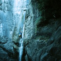
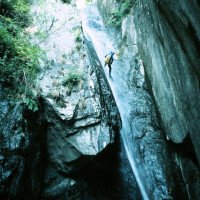
Tour (3 h 20):
machine translated
➜
Original language
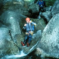
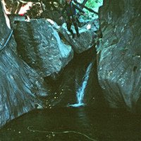
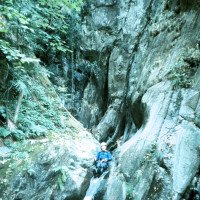
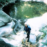
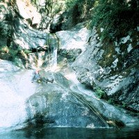
Landschaftlich überrascht die Tour durch die vielen Palmen, die mitten in der Schlucht wachsen. Wohl deshalb bekam die Schlucht von Luca Nizzola den Namen Ri delle Palme.\nDa einige Abseilstrecken voll durch die Wasserlinie führen ist ein genaues Begutachten des Wasserstandes vor der Tour unerlässlich! Wasserstandskontrolle: Fährt man in Gudo von der Hauptstraße Bellinzona-Locarno rechts ab beim Ristorante "Cottini und weiter in Richtung "Cantina Ramelli", überquert man unseren Bach. Die unterhalb der Brücke gelegene Stufe darf maximal 5 cm hoch überflutet sein.\nDas Geläuf im Bach ist sehr glitschig!
Scenic, the tour surprises by the many palm trees that grow in the middle of the canyon. This is probably why Luca Nizzola named the canyon Ri delle Palme.\nSince some rappelling routes lead right through the water line, it is essential to check the water level before the tour! Water level check: If you leave the main road Bellinzona-Locarno in Gudo and turn right at the Ristorante "Cottini" and continue in the direction of "Cantina Ramelli", you will cross our stream. The steps below the bridge must not be flooded more than 5 cm.\nThe terrain in the stream is very slippery!
Return (10 min):
machine translated
➜
Original language
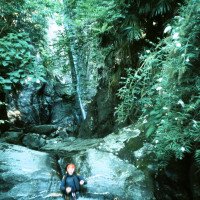
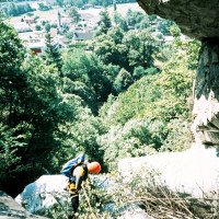
Nach der letzten Rutsche mit einem Fixseil auf der linken Seite (besser von dem Baum rechts abseilen!) und dem deutlichen Ende der Schlucht führt links eine Metalltreppe aus dem Bach und ein Weg hoch zu einem rot-gelb gestrichenen Gebäude. Hier durch den Durchgang nach rechts und runter zur Straße (Privatgelände!-will man Ärger vermeiden, so weiter bachab aussteigen!). Auf der Straße nach links in wenigen Metern zum Auto.\nNach der Hälfte der Tour besteht eine Ausstiegsmöglichkeit nach links zum Aufstiegsweg auf einem Weg, der den Bach kreuzt.
After the last slide with a fixed rope on the left (better rappel from the tree on the right!) and the clear end of the canyon, a metal staircase leads out of the creek on the left and a path up to a red-yellow painted building. Here through the passage to the right and down to the road (private property!-if you want to avoid trouble, so get out further down the creek!). On the road to the left in a few meters to the car.\nAfter half of the tour there is an exit possibility to the left to the ascent path on a path that crosses the stream.
Coordinates:
Canyon Start
46.1796°, 8.94377°
↓↑
DMS: 46° 10" 46.56', 8° 56" 37.57'
DM: 46° 10.776", 8° 56.626"
Google Maps
SwissTopo
DMS: 46° 10" 46.56', 8° 56" 37.57'
DM: 46° 10.776", 8° 56.626"
Google Maps
SwissTopo
Canyon End
46.1758°, 8.9419°
↓↑
DMS: 46° 10" 32.88', 8° 56" 30.84'
DM: 46° 10.548", 8° 56.514"
Google Maps
SwissTopo
DMS: 46° 10" 32.88', 8° 56" 30.84'
DM: 46° 10.548", 8° 56.514"
Google Maps
SwissTopo
Waterlevel Meter Site
46.17452°, 8.93991°
↓↑
DMS: 46° 10" 28.27', 8° 56" 23.68'
DM: 46° 10.471", 8° 56.395"
Google Maps
SwissTopo
DMS: 46° 10" 28.27', 8° 56" 23.68'
DM: 46° 10.471", 8° 56.395"
Google Maps
SwissTopo
Ebenfalls Parkmöglichkeit
Parking Entry and Exit
46.17598°, 8.94408°
↓↑
DMS: 46° 10" 33.53', 8° 56" 38.69'
DM: 46° 10.559", 8° 56.645"
Google Maps
SwissTopo
DMS: 46° 10" 33.53', 8° 56" 38.69'
DM: 46° 10.559", 8° 56.645"
Google Maps
SwissTopo
Literatures:
Map
CNS 1313, Bellinzona, 1 : 25 000
Canyoning Book
Canyoning-Touren Schweiz 2
F. Baumgartner / A. Brunner / D. Zimmermann
2010
Canyoning Book
Eldorado Ticino
Anna Nizzola / Luca Nizzola
2010
Canyoning Book
Swiss Alps Canyoning VOL. 2.0
Matthias Holzinger & Thomas Guigon
Pixartprinting.ch
2020
Cwiki Canyon Info
Descente Canyon Info
Ropewiki Canyon Info
Swisscanyon Canyon Info
Schlucht.ch Canyon Info
New Report
20.04.2024
Jeanne
⭐
★★★★★
📖
★★★
⚓
★★★
💧
Normal
Completed ✔
no translation available
Automatisch importiert von Descente-Canyon.com für Canyon Progero (inférieur)
DC+
(Quelle: https://www.descente-canyon.com/canyoning/canyon-debit/2678/observations.html)
20.04.2024
Alex Arnold
⭐
★★★★★
📖
★★★
⚓
★★★
💧
High
Completed ✔
machine translated
➜
Original language
Passt. Tolle Frühlingstour
Mountain pass. Great spring tour
08.04.2024
freecanyon
⭐
★★★★★
📖
★★★
⚓
★★★
💧
High
Completed ✔
no translation available
Automatisch importiert von Descente-Canyon.com für Canyon Progero (inférieur)
RAS, superbes conditions ce jour. Les deux grandes poussent un peu !
(Quelle: https://www.descente-canyon.com/canyoning/canyon-debit/2678/observations.html)
26.11.2023
Patrik B
⭐
★★★★★
📖
★★★
⚓
★★★
no translation available
Automatisch importiert von Schlucht.ch für Canyon Valle di Progero / Riale delle Palme, Wasserstand: "Mittel" Verankerungen: "Gut"
(Quelle: https://schlucht.ch/schluchten-der-schweiz.html?cid=88)
03.04.2023
Daniel Sturm
⭐
★★★★★
📖
★★★
⚓
★★★
Completed ✕
machine translated
➜
Original language
Koordinaten & Beschreibung angepasst.
Coordinates & description adjusted.
09.03.2023
System User
⭐
★★★★★
📖
★★★
⚓
★★★
no translation available
Daten importiert von https://canyon.carto.net/cwiki/bin/view/Canyons/ProgeroCanyon.html