not as difficult
Krebsbach
Country:
Österreich / Austria
Region: Tirol
Subregion: Bezirk Imst
Town: Stams
v3 a1 III
1h55
20min
1h30
5min
790m
660m
130m
20m
16
400m
on Foot
Rating:
★★★★★
2.5 (1)
Info:
★★★
2 (1)
Belay:
★★★
1 (1)
Summary:
machine translated
➜
Original language
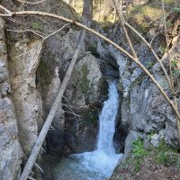
Wird in Veranstalterkreisen Krebsbach genannt; dieser mündet kurz oberhalb in den Lehnbach.Reiner Abseilcanyon, einfache Tour mit wenig Wasser, sehr sonnig, daher vermutlich ganzjährig begehbar, außer bei viel Schnee. Leider sehr stark verschmutzt und vermüllt durch Abfälle/Abwasser aus dem stark besiedelten Mieminger Plateau.
In organizer circles called Krebsbach; this flows shortly above into the Lehnbach.pure rappel canyon, easy tour with little water, very sunny, therefore probably passable throughout the year, except when there is a lot of snow. Unfortunately, very heavily polluted and littered by waste / sewage from the heavily populated Mieminger Plateau.
May - October
29.93km²
Summary:
machine translated
➜
Original language
Wird in Veranstalterkreisen Krebsbach genannt; dieser mündet kurz oberhalb in den Lehnbach.Reiner Abseilcanyon, einfache Tour mit wenig Wasser, sehr sonnig, daher vermutlich ganzjährig begehbar, außer bei viel Schnee. Leider sehr stark verschmutzt und vermüllt durch Abfälle/Abwasser aus dem stark besiedelten Mieminger Plateau.
In organizer circles called Krebsbach; this flows shortly above into the Lehnbach.pure rappel canyon, easy tour with little water, very sunny, therefore probably passable throughout the year, except when there is a lot of snow. Unfortunately, very heavily polluted and littered by waste / sewage from the heavily populated Mieminger Plateau.
Access:
machine translated
➜
Original language
Von der Inntalautobahn über die Ausfahrt Mötz auf die Bundesstrasse Richtung Innsbruck, bei Stams nach dem letzten Haus links abbiegen und Richtung "Wasserfall" fahren. Am Straßenende auf dem Parkplatz vor der Autobahnunterführung das Auto abstellen.
From the Inntal freeway take the Mötz exit onto the main road in the direction of Innsbruck, at Stams turn left after the last house and drive in the direction of "Wasserfall". At the end of the road, park your car in the parking lot in front of the highway underpass.
Approach (20 min):
machine translated
➜
Original language
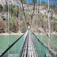
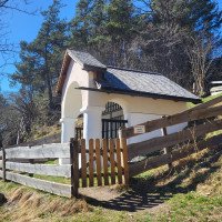
Durch die Unterführung und über die Hängebrücke ans nördliche Innufer und auf dem Wanderweg Richtung Untermieming hochsteigen. Nach Passieren einer Kapelle gleich rechts am Rand der Wiese auf kleinem Pfad und weiter am Waldrand hinunter zum Bach. (Etwas oberhalb steht am linken Ufer die Ruine einer Mühle.)
Go through the underpass and over the suspension bridge to the northern bank of the Inn River and climb up on the hiking trail in the direction of Untermieming. After passing a chapel, immediately turn right at the edge of the meadow on a small path and continue along the edge of the forest down to the stream. (A little above on the left bank is the ruin of a mill).
Tour (1 h 30):
machine translated
➜
Original language
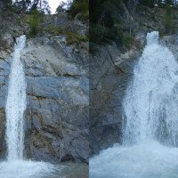
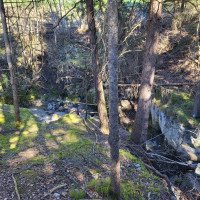
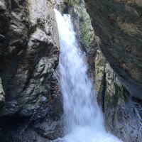
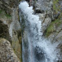
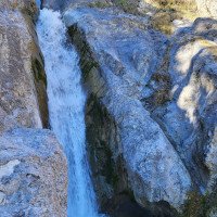
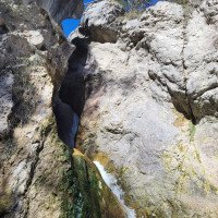
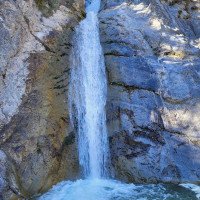
Insgesamt 15 Abseilstellen, zum Teil sehr weit außerhalb des eigentlichen Bachbetts, mit Kettenständen und einigen Drahtseilen, um zum Stand zu gelangen. Es besteht aber die Möglichkeit, im unteren Teil auch dem Bachlauf zu folgen. Der Schlusswasserfall wird in zwei Etappen abgeseilt (sonst längere Seile nötig).Oberhalb Wasserableitung zu einem Kraftwerk.
A total of 15 rappelling points, some very far outside the actual streambed, with chain anchors and some wire ropes to get to the belaystation. However, it is possible to also follow the course of the stream in the lower part. The final waterfall is rappelled in two stages (otherwise longer ropes are needed).Above water diversion to a power station.
Return (5 min):
machine translated
➜
Original language
Rechts am Kraftwerk vorbei auf Fußweg zurück zur Hängebrücke und zum Auto.
Pass the power station on the right and take the footpath back to the suspension bridge and the car.
Coordinates:
Canyon Start
47.2889°, 10.9861°
↓↑
DMS: 47° 17" 20.04', 10° 59" 9.96'
DM: 47° 17.334", 10° 59.166"
Google Maps
Austria Topo
DMS: 47° 17" 20.04', 10° 59" 9.96'
DM: 47° 17.334", 10° 59.166"
Google Maps
Austria Topo
Canyon End
47.2874°, 10.9875°
↓↑
DMS: 47° 17" 14.64', 10° 59" 15'
DM: 47° 17.244", 10° 59.25"
Google Maps
Austria Topo
DMS: 47° 17" 14.64', 10° 59" 15'
DM: 47° 17.244", 10° 59.25"
Google Maps
Austria Topo
Parking Entry and Exit
47.28489°, 10.98489°
↓↑
DMS: 47° 17" 5.6', 10° 59" 5.6'
DM: 47° 17.093", 10° 59.093"
Google Maps
Austria Topo
DMS: 47° 17" 5.6', 10° 59" 5.6'
DM: 47° 17.093", 10° 59.093"
Google Maps
Austria Topo
Google Maps: https://maps.app.goo.gl/jqBbdCXMoJH9zzRG9
Literatures:
Map
freytagberndt WK 322 'Wetterstein'
Canyoning Book
Tiroler Canyoningführer
Alexander Riml / Gunnar Amor
2012
New Report
25.03.2024
Clarissa Linder
⭐
★★★★★
📖
★★★
⚓
★★★
💧
Normal
Completed ✔
machine translated
➜
Original language
Schlucht im Vergleich zu vor 3 Jahren stark verändert, einige Stände wären zu erneuern. Leider viel Müll in der Schlucht :(
Canyon has changed a lot compared to 3 years ago, some stands would have to be renewed. Unfortunately a lot of garbage in the canyon :(
09.03.2023
System User
⭐
★★★★★
📖
★★★
⚓
★★★
no translation available
Daten importiert von https://canyon.carto.net/cwiki/bin/view/Canyons/KrebsbachCanyon.html
Hydrology: