Country:
Schweiz / Switzerland
Region: Kanton Tessin / Cantone Ticino
Subregion: Bezirk Locarno
Town: Verzasca
v4 a5 V
4h30
1h15
3h
15min
880m
520m
360m
40m
2x50m
2400m
on Foot
Rating:
★★★★★
0 ()
Info:
★★★
0 ()
Belay:
★★★
0 ()
Summary:
machine translated
➜
Original language
Abseilcanyon mit Rutschen und Springen mit glasklarem Wasser und Gumpen. Abseiler sind teils im Wasser. Viele Stellen können gesprungen werden. 2 große Rutschen wo keine Hacken sind, sollten zuvor aber geprüft werden.
Sehr lohnende, recht aquatische Schlucht mit schöner Felszeichnung.
Rappel canyon with slides and jumps with crystal clear water and pools. Rappels are partly in the water. Many places can be jumped. 2 large slides where there are no hooks should be checked beforehand.
June - October
9-16 o clock
Summary:
machine translated
➜
Original language
Abseilcanyon mit Rutschen und Springen mit glasklarem Wasser und Gumpen. Abseiler sind teils im Wasser. Viele Stellen können gesprungen werden. 2 große Rutschen wo keine Hacken sind, sollten zuvor aber geprüft werden.
Sehr lohnende, recht aquatische Schlucht mit schöner Felszeichnung.
Rappel canyon with slides and jumps with crystal clear water and pools. Rappels are partly in the water. Many places can be jumped. 2 large slides where there are no hooks should be checked beforehand.
Access:
machine translated
➜
Original language
Verzascatal: An der Berühmten Römerbrücke in Laverezzo vorbei bis ein großer Parkplatz links kommt. Auf diesem darf man den ganzen Tag parken. Bitte darauf achten, dass ihr am Parkautomat das 10 Fr. Tagesticket kauft. 3 Std kosten 5 Fr. Es wird dort geprüft und ein Strafzettel kostet 40 Fr. Bezahlung mit Franken oder EC Karte möglich.
Verzasca Valley: Pass the famous Roman bridge in Laverezzo until you reach a large parking lot on the left. You can park there all day. Please make sure that you buy the 10 Fr. day ticket at the parking machine. 3 hours cost 5 Fr. It is checked there and a parking ticket costs 40 Fr. Payment is possible with francs or EC card.
Approach (1 h 15):
machine translated
➜
Original language
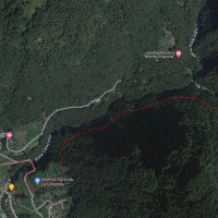
Man läuft zurück nach Laverezzo und geht über die erste Straße links hoch, über eine Brücke und weiter bis zum Bergdorf. An der ersten Steinmauer in der Linkskurve nach der Brücke kann man links die Wiese hochlaufen und kommt an einem Haus vorbei. Es kommt einem vor als wäre man hier auf privaten Grundstück. Den Weg/Stufen immer weiter, bis man auf eine Handvoll Häuser trifft wo ein Trinkbrunnen ist. Von da immer den Weg/Stufen weiter hoch in den Wald. Ab hier gibt es Wandermarkierungen. Im Wald immer der Schlucht nach oben bis zu einer Hängebrücke. Diese quert man und hat eine tollen blick in die Gumpen. An dieser Brücke kann man später aussteigen. Eventuell ist es angebracht ein kurzes Seil in den Hang zu legen. Der Hang sieht klitschig und steil aus. Es folgt der 2 Anstieg im Wald. Irgendwann kommt man auf die Höhe vom Fluss. Dort ist dann auch der Einstieg. Es soll noch einen oberen Teil geben. Darüber habe ich aber keine Info.
Walk back to Laverezzo and take the first road on the left uphill, over a bridge and on to the mountain village. At the first stone wall in the left-hand bend after the bridge, you can walk up the meadow to the left and pass a house. It feels like you are on private property here. Continue along the path/steps until you come to a handful of houses where there is a drinking fountain. From there, continue up the path/steps into the forest. From here there are hiking markings. In the forest, follow the canyon upwards until you reach a suspension bridge. Cross this and you have a great view of the pools. You can get off at this bridge later. It may be advisable to lay a short rope in the slope. The slope looks slippery and steep. The 2nd ascent in the forest follows. At some point you reach the height of the river. This is also the entry point. There is supposed to be an upper part. But I have no information about that.
Tour (3 h):
machine translated
➜
Original language
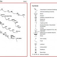
Die erste Rutsche kommt relativ am Anfang. Es gibt dort keinen Hacken. Vor den Rutschen sollte man den Gumpen prüfen. Einen Hacken dort neu setzen wäre von Vorteil. Bei einem Abseiler liegt der Hacken unter einem großen Felsblock im Wasserlauf. Dort sollte der erste über eine Mannsicherung gesichert werden und ein Seilgeländer bauen. Es soll aber auch eine Abseilstelle hinter dem Felsblock geben der außerhalb vom Wasser ist. Auch an dieser stelle wäre ein Hacken vor der Abseilstelle sinnvoll um ein Seilgelände bauen zu können. Wenn man wieder an der Hängebrücke unten ankommt, kann man links aussteigen. Wenn man weiter geht, sollte man zuvor im Ort den Wasserstand geprüft haben. Der Wasserzufluss vom Real Agro sieht man anhand der großen Felsblöcke nur schlecht. Alles was danach kommt ist sehr Wasserreich mit langen Schwimmstellen. Es folgen noch tolle Sprungkumpen mit 30-40m Schwimmstrecken. Für diesen Teil benötigt man ca. 1,5 Std.
The first slide comes relatively at the beginning. There is no hook there. You should check the pool before the slides. It would be an advantage to place a new piton there. In the case of a rappel, the piton is under a large boulder in the watercourse. The first person should be secured there with a man belay and a rope traverse should be built. However, there should also be an abseiling point behind the boulder that is outside the water. Here, too, it would be useful to have a hook in front of the abseiling point to build a rope traverse. When you get back to the suspension bridge at the bottom, you can get off to the left. If you continue, you should have checked the water level in the village beforehand. The water inflow from the Real Agro is difficult to see because of the large boulders. Everything that follows is very watery with long swimming spots. This is followed by great jumping pools with 30-40m swimming sections. This part takes about 1.5 hours.
Return (15 min):
machine translated
➜
Original language
Entweder bei der Hängebrücke aussteigen oder weiter bis im Dorf ankommt. Ausstieg jeweils links.
Either get off at the suspension bridge or continue until you reach the village. Exit on the left in each case.
Coordinates:
Parking Entry and Exit
46.262333°, 8.830888°
↓↑
DMS: 46° 15" 44.4', 8° 49" 51.2'
DM: 46° 15.74", 8° 49.853"
Google Maps
SwissTopo
DMS: 46° 15" 44.4', 8° 49" 51.2'
DM: 46° 15.74", 8° 49.853"
Google Maps
SwissTopo
Canyon Start
46.260282°, 8.868367°
↓↑
DMS: 46° 15" 37.01', 8° 52" 6.12'
DM: 46° 15.617", 8° 52.102"
Google Maps
SwissTopo
DMS: 46° 15" 37.01', 8° 52" 6.12'
DM: 46° 15.617", 8° 52.102"
Google Maps
SwissTopo
Waypoint
46.257835°, 8.841722°
↓↑
DMS: 46° 15" 28.21', 8° 50" 30.2'
DM: 46° 15.47", 8° 50.503"
Google Maps
SwissTopo
DMS: 46° 15" 28.21', 8° 50" 30.2'
DM: 46° 15.47", 8° 50.503"
Google Maps
SwissTopo
Wegpunkt Zustieg
Canyon End
46.257907°, 8.839885°
↓↑
DMS: 46° 15" 28.46', 8° 50" 23.59'
DM: 46° 15.474", 8° 50.393"
Google Maps
SwissTopo
DMS: 46° 15" 28.46', 8° 50" 23.59'
DM: 46° 15.474", 8° 50.393"
Google Maps
SwissTopo
Schlucht.ch Canyon Info
New Report
Hydrology:
machine translated
➜
Original language
Es gibt kein Kraftwerk oder Wasserableitung
There is no power plant or water drainage

