Country:
Österreich / Austria
Region: Kärnten
Subregion: Bezirk Villach-Land
Town: Finkenstein am Faaker See
v2 a2 II
2h45
1h
1h
45min
1200m
1100m
100m
18m
2x25m
6
200m
on Foot
Rating:
★★★★★
1 (1)
Info:
★★★
2 (1)
Belay:
★★★
2 (1)
Summary:
machine translated
➜
Original language
Wilde einsame Canyonlandschaft am Fuße der Mittagskogel Nordwand. Kann ohne Neopren begangen werden, alle Abseiler sind außerhalb des Wassers. Becken gibt es so gut wie keine.
Wild, lonely canyon landscape at the foot of the Mittagskogel north face. Can be done without neoprene, all rappels are out of the water. There are virtually no pools.
North
Limestone
Summary:
machine translated
➜
Original language
Wilde einsame Canyonlandschaft am Fuße der Mittagskogel Nordwand. Kann ohne Neopren begangen werden, alle Abseiler sind außerhalb des Wassers. Becken gibt es so gut wie keine.
Wild, lonely canyon landscape at the foot of the Mittagskogel north face. Can be done without neoprene, all rappels are out of the water. There are virtually no pools.
Access:
machine translated
➜
Original language
Beim Hotel Mittagskogel geht es rauf nach Kopein. Den Wanderwegweisern mit dem Auto folgen Richtung Bertahütte. Parken bei der Kurve "Illitsch Rauth auf 900m Seehöhe. In dieser Kurve sieht man das erste mal den Bach und hier parken.
At the Hotel Mittagskogel, head up to Kopein. Follow the hiking signs by car in the direction of Bertahütte. Park at the bend "Illitsch Rauth at 900m above sea level. At this bend you will see the stream for the first time and park here.
Approach (1 h):
machine translated
➜
Original language
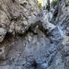
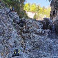
Von der Kote 900 die Straße entlang bis zum offiziellen Parkplatz der Bertahütte auf 1150m Seehöhe (30min). Hier geht es nach dem Schranken noch 250m die Schotterstraße rauf und beim ersten Weg nach west abbiegen. Nach 100m bei der Futterkrippe den Hang Weglos Richtung SW aufsteigen zu den Felswänden ca 150m, am Wandfuß weiter Richtung SW und man kann den kleinen Sattel den man mit allen vieren erklimmen muss bereits erkennen. Am Sattel angekommen entweder von der dicken Fichte 20m Abseilen oder über Bänder/Geröll sehr steil in den Hochwald absteigen. Im Hochwald weiter leicht fallend nach West zum Bach. Den Bachlauf für 10min folgen und man ist beim ersten Abseiler / Kletterstelle.
From Kote 900 follow the road to the official parking lot of the Bertahütte at 1150m above sea level (30min). After the barrier, continue up the gravel road for another 250m and turn west at the first path. After 100m at the Futterkrippe, ascend the slope without a path in a SW direction to the rock faces approx. 150m, at the foot of the wall continue in a SW direction and you can already recognize the small saddle that you have to climb with all fours. Once at the saddle, either rappel 20m from the thick spruce or descend very steeply over ledges/scree into the high forest. In the high forest, continue slightly downhill to the west to the stream. Follow the stream for 10 minutes and you are at the first rappel/climbing point.
Tour (1 h):
machine translated
➜
Original language
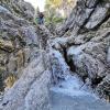
1: Baumabseiler, 7m, eventuell Kletterbar
2: der geteilte Wasserfall, 15m, Kette li
3: der Stufenfall, 15m, Kette re, Achtung scharfe Kante, in der Nähe vom Wasser bleiben.
4: die Nasse Rampe, sehr rutschig, 6m, Kette li
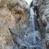
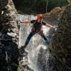
5: Hauptwasserfall, 18m, Kette re hoch oben, man kann direkt neben dem Wasserfall abseilen, 2x25m Seil Notwendig. Seilt man sich etwas trockener 6m daneben ab sind aber 2x30m Notwendig. Hier gibt es auch ein Not Ausstiegsseil raus in den Wald.
6: Bröselkante Abseiler, 6hm, Kette li oben bei einer Harnischfläche.
Rückweg 30-45min den Bach entlang, dazwischen kleine Kletterstellen, eine kurze alte Aluleiter und unzählige male den Bach queren. Bei der Geröllsperre in 1 min zum Auto.
1: tree abseil, 7m, possibly climbing bar
2: the split waterfall, 15m, chain left
3: the step fall, 15m, chain right, watch out for sharp edges, stay close to the water.
4: the wet ramp, very slippery, 6m, chain left
5: Main waterfall, 18m, chain right high up, you can rappel right next to the waterfall, 2x25m rope necessary. If you rappel a little drier 6m next to it, 2x30m are necessary. There is also an emergency exit rope out into the forest.
6: Bröselkante rappel, 6m, chain left at the top of a harness area.
Return 30-45min along the stream, in between small climbing sections, a short old aluminum ladder and countless crossings of the stream. At the scree barrier 1 min to the car.
Return (45 min):
machine translated
➜
Original language
Rückweg 30-45min den Bach entlang, dazwischen kleine Kletterstellen, eine kurze alte Aluleiter und unzählige male den Bach queren. Bei der Geröllsperre in 1 min zum Auto.
Return 30-45min along the stream, in between small climbing sections, a short old aluminum ladder and countless crossings of the stream. At the scree barrier, 1 min to the car.
Coordinates:
Parking Entry and Exit
46.53627°, 13.94439°
↓↑
DMS: 46° 32" 10.57', 13° 56" 39.8'
DM: 46° 32.176", 13° 56.663"
Google Maps
Austria Topo
DMS: 46° 32" 10.57', 13° 56" 39.8'
DM: 46° 32.176", 13° 56.663"
Google Maps
Austria Topo
Parkplatz für 5 Autos
Canyon Start
46.52035°, 13.94801°
↓↑
DMS: 46° 31" 13.26', 13° 56" 52.84'
DM: 46° 31.221", 13° 56.881"
Google Maps
Austria Topo
DMS: 46° 31" 13.26', 13° 56" 52.84'
DM: 46° 31.221", 13° 56.881"
Google Maps
Austria Topo
Canyon End
46.52186°, 13.9485°
↓↑
DMS: 46° 31" 18.7', 13° 56" 54.6'
DM: 46° 31.312", 13° 56.91"
Google Maps
Austria Topo
DMS: 46° 31" 18.7', 13° 56" 54.6'
DM: 46° 31.312", 13° 56.91"
Google Maps
Austria Topo
New Report
10.05.2024
Friedl Martin
⭐
★★★★★
📖
★★★
⚓
★★★
💧
High
Completed ✔
machine translated
➜
Original language
Nach dem Winter ist alles OK, alle Stände vorhanden. Ein neuer Stand wurde bei Wasserfall 4 eingerichtet, den beim Hauptstand ist für eine Trockenbegehung zu viel Wasser.
After the winter everything is OK, all stands are in place. A new stand was set up at waterfall 4, as there is too much water at the main stand for a dry ascent.
Hydrology:
machine translated
➜
Original language
Aufzupassen ist nach langen Regenfällen und Gewittern. Flashflood Gefahr. Das Wasser kann innerhalb kürzester Zeit 2 bis 3 m über Bachniveau ansteigen. Abgerissene Anker zeugen von dieser Kraft.
Be careful after long rainfalls and thunderstorms. Flashflood danger. The water can rise 2 to 3 meters above stream level within a very short time. Broken anchors are evidence of this force.

Topo Mittagskogelschlucht /...

sehr viel Sand, Lehm und Sed...

erster Abseiler am kleinen B...

2. Abseiler, Kette li

4. Abseiler, Kette li

6. Abseiler, Kette li

die Farbunterschiede sind de...
Baumabseiler

2. Abseiler, Kette li

3. Abseiler, Kette re

der rutschige Abseiler

Hauptwasserfall C18

das Gelände oberhalb der Sch...

der Rückweg ist immer wieder...